Showing posts with label City of Detroit. Show all posts

Monday, January 24, 2011

Shutter ball

Forty-five years ago, bowling was a major part of Detroit life.  In 1966, residents were so taken by the game that the City Council passed an ordinance – DCO § 38-5-5 – that specifically banned bowling in streets and alleys. That same year, the city took ownership of the Manoogian Mansion, the only mayoral residence in the country with a private bowling lane.  The city was home to tens of thousands of avid bowlers and 47 bowling alleys.

Although 1966 may have been a high-water mark for bowling in Detroit, it built upon a long history of bowling in the city. Thirty years earlier, the Stroh's Bohemian Beers Detroit team represented the United States at the 1936 Olympics in Berlin, when bowling was a demonstration sport. (I’m proud to note that my great-great-uncle, Wally Reppenhagen, pictured at far right, was on that Stroh team.)


The post-war period saw a surge in interest in bowling. In the 1950's, ace bowler, and then-Detroit Mayor, Albert Cobo often decided city policy while bowling. He was such a fan of the game that he advocated for adding bowling alleys in public high schools while mayor.  At the time, many of the city's churches had bowling alleys in the basement.


According to the 1966 Detroit Yellow Pages, Detroit was home to 47 bowling alleys in 1966, a period when bowling was at its height. Especially when comparing the city’s east and northwest sides, it’s clear that bowling alleys were highly concentrated in the city’s working class neighborhoods, especially in areas home to concentrations of German and Polish residents.


Unfortunately, with the tremendous loss of residents of German and Polish ancestry, bowling no longer enjoys its once-prominent role in city life. Today,  most Detroiters aren’t bowling alone – they aren’t bowling at all. According to 2010 City of Detroit licensing data, the city has only two bowling alleys: The Garden Bowl and the Renaissance Bowling Center.  This is a sad state for the once-proud sport in the city.  Bowling alleys were centers for communities and anchors for neighborhoods.  


On February 1st – the 209th anniversary of Detroit’s incorporation as a city – celebrate the city’s past and preserve a Detroit tradition: go bowling.  Visit one of Detroit's fine bowling alleys:
  • The Garden Bowl is located at 4120 Woodward Ave.
  • Renaissance Bowling Center is located at 19600 Woodward Ave.

See you on the lanes.

*Special thanks to Detroit legend Bill McGraw for cluing me into the yellow pages as a source for historical data.  You will notice it again in next week's post questioning the "food desert" label.*

Wednesday, December 15, 2010

Space-age Transit

In honor of Metro Detroit’s ongoing transit-planning process, this is the first post in a series looking at previous transit planning efforts. Although the city has a storied – and well-documented – transit history, the city’s transit planning history remains more of a mystery.

City records suggest that Detroit’s first transit planning effort began in 1914, with a proposal by the long-defunct Board of Street Railway Commissioners for a subway along Woodward between Jefferson and Milwaukee. Subsequent Detroit transportation authorities – primarily the Rapid Transit Commission – have produced more than 20 wide-ranging plans that evolved with the city, transit technology, and public opinion. Among these plans is one of my favorites, the Miriani-era 1958 Rapid Transit System And Plan Recommended For Detroit And The Metropolitan Area.


At its core, Rapid Transit Commission’s space-age 1958 plan called for the city to construct an elaborate network of elevated, suspended “duorail” lines along the city’s arterial roadways, with spur lines along some of the outlying major east/west and north/south roadways. This system was to be built upon 28’ tall, concrete and steel “T” and inverted “L” shaped pylons that would support tracks for the large, 58’ long boat-shaped cars. As this artist’s rendering shows, the cars were to hang from the tracks, 18’ feet off the ground. Although cars were supposed to have an average speed of 40 mph along busy routes, the cars were to exceed 70 mph in outlying areas.


The plan identifies seven reasons why Detroit and its suburbs need a unified transit system, including current concerns such as reducing congestion, increasing accessibility, and encouraging compact commercial development. It’s greatest concern, however, was that the CBD was beginning to decline. As the plan notes, “…downtown valuations [assessed value] decreased by 38.5% between 1930 and 1953, and citywide valuations had no change. What is indisputably evident here is the definite and gradual decline of the property valuations not only in the central business district but also along the major commercial thoroughfares in the city.” The commission strongly believed that these space-age trains would draw people to arterial commercial zones and the CBD, and reinvigorate these areas.


This artist’s rendering is supposed to illustrate the benefits of overhead transit to the Book Cadillac area of downtown. (Please ignore the potentially illicit transaction occurring in the lower right-hand corner.)


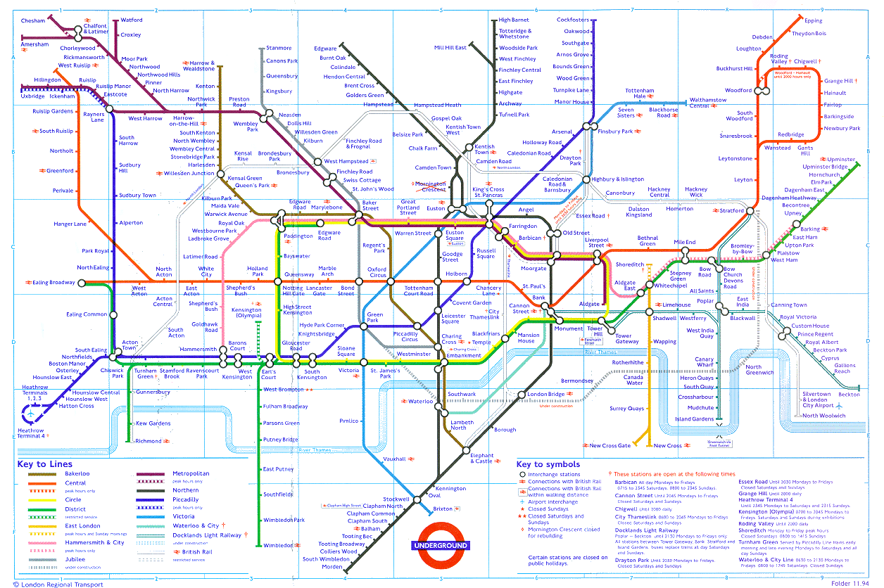
But just how would this look for the city and the region? Based on the lists of routes and stops provided (no map was included, oddly) I’ve mapped out the system, in the London-subway-map style.


The plan does not outline the exact routes beyond the city’s boundaries, so I’ve just indicated their final destinations. What is most interesting about this plan, perhaps, is the distribution of service - the areas east of Woodward have a far greater concentration given the area's relative size and population, compared to the west side. The choices for suburban terminuses - Mt. Clemens, Pontiac, Farmington, Ypsilanti, Grosse Pointe and Rockwood - illustrate the evolution of the suburbs; today, only two of these - Mt. Clemens and Pontiac - are commonly discussed as possible transit destinations.


Today, as much as in 1958, the City of Detroit needs more transit options. Hopefully, by evaluating our past we can better plan our future.

Saturday, November 27, 2010

Last House on the Prairie

Journalists - and particularly out-of-town journalists - seem obsessed with the life of the city's most isolated residents. A typical news story about the city's developing right-sizing plan almost always begins by interviewing an isolated resident whose house is the last one on the block. In a standard article, this homeowner usually bemoans their isolated location, but insists that they will never leave. These stories usually cite these residents as both a reason for, and an obstacle to, efforts to right-size the city.

NPR, The Huffington Post, Time Magazine, Lost Magazine, The Metro Times, Harper's Magazine, Fox 2 News, Forbes, and Architect Magazine all subscribe to this narrative. In fact, almost every national or local paper - except for the Detroit Free Press and Model D - has run at least one article on the city featuring an interview with one of these "last house on the block" (LHB) residents. NewsBank and Lexis Nexis return stories from more than 30 newspapers featuring an LHB resident. This resident on St. Aubin, for example, was interviewed earlier this year.


But just how common are these rural Detroiters? Does the size of the city's LHB population warrant the attention? Using Detroit Residential Parcel Survey and City of Detroit data, I tried to measure this phenomenon. I used the radius of a short block, 300 feet, as my threshold for isolation - if a resident's nearest neighbor was more than 300' away, I included them as a LHB.

Perhaps Detroit is not home to enough rural residents to warrant the attention. In total, only 134 occupied homes in the city were more than 300' from the nearest occupied home in 2009.

Wednesday, November 17, 2010

Detroit's Liquor Stores

According to liquor license data provided by the Michigan Liquor Control Commission, Detroit leads the state in liquor sales and active liquor licenses. Not only does Detroit have the most active liquor licenses of any local jurisdiction, but the city's liquor stores, bars, and alcohol-serving restaurants have higher liquor sales than any city or county in the state.

Based on 2009 liquor tax collection data, this graph shows that Detroit sells more liquor than the rest of Wayne County or any other city or county in the state.

Similarly, Detroit had the most liquor licenses per resident (measured here as residents per liquor license to avoid comparing small fractions) in 2009.

Clearly, no area in the city is without a liquor store or bar. In fact, every resident of the city lives within .7 miles of one of the city's 810 liquor stores or 560 bars.

Sunday, November 7, 2010

Michael Kelly & Matthew Tatarian, Continued

This map may offer more concrete evidence of Michael Kelly and Matthew Tatarian's business model. This map, created using SEMCOG and City of Detroit Assessor data, shows the properties owned by Kelly and Tatarian, and notes whether the properties are within 45' of a parcel owned by the City of Detroit, the Wayne County Land Bank, or a local non-profit. (I excluded the State of Michigan, Wayne County or the Federal Government because these governments do not usually collect property for parcel assembly- rather, they usually focus on disposition.) I chose this distance based on the distribution of street widths and lot frontages throughout the city - nearly all of the city's lots are between 30 and 40 feet wide. Using this metric, a 45' radius includes properties adjacent to, and two doors down from, a Kelly-owned property without including properties further away. Similarly, this radius includes properties across alleys and streets, without including properties across both a street and an alley.

Clearly, this map suggests that Kelly and Tatarian seek properties in areas near properties owned by non-profits and property-assembling governments. Nearly 75% (1048/1405) of properties owned by Kelly and Tatarian are within 45' of city- or non-profit-owned properties, about twice the rate for other properties.

Sunday, October 24, 2010

Density of Vacant Lots and City-owned Property

Ultimately, it seems that the City of Detroit becomes the owner of the the city's most vacant areas. This map attempts to illustrate this point. Look at the close correlation between the areas with the greatest concentration of vacant land and the ares with the greatest concentration of city-owned land. Click on the image to see a much larger version.

This map was made with City of Detroit Planning & Development Department and City of Detroit Assessor data.